
LIDAR TECHNOLOGY SOLUTION
LiDAR Technology Solutions
LiDAR (Light Detection and Ranging) is a cutting-edge technology that has transformed the way we capture, analyze, and utilize spatial data. By using laser pulses to measure distances with high precision, LiDAR provides accurate 3D information about the earth’s surface, natural environments, and man-made structures. LiDAR technology solutions are now widely adopted across industries such as surveying, construction, infrastructure, transportation, mining, forestry, and urban planning.
Precision and Accuracy
LiDAR delivers highly detailed 3D models with centimeter-level accuracy, making it ideal for applications where precision is critical. Whether it’s mapping terrain, assessing vegetation cover, or monitoring structural changes, LiDAR ensures accurate data that improves decision-making and project efficiency.
Applications in Infrastructure and Construction
In construction and infrastructure projects, LiDAR is used for topographic surveys, digital elevation models (DEM), and site monitoring. Engineers and planners rely on LiDAR to evaluate ground conditions, detect obstructions, and design layouts that align with real-world conditions. This minimizes errors, reduces costs, and accelerates project timelines.
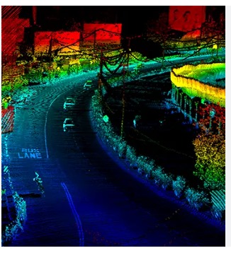
Transportation and Road Networks
For transportation and road projects, LiDAR solutions help in route planning, highway design, and pavement assessment. High-resolution LiDAR data enables authorities to improve road safety, optimize traffic management, and plan smart cities with better connectivity.
Environmental and Natural Resource Management
LiDAR also plays a significant role in environmental studies. It assists in forest canopy analysis, floodplain mapping, watershed management, and coastal monitoring. The technology’s ability to penetrate vegetation makes it valuable for ecological assessments and disaster management.
Future-Ready Technology
As demand for digital transformation grows, LiDAR solutions are being integrated with drones, GIS platforms, and AI-based analytics. This combination offers faster, safer, and more cost-effective data collection methods, making LiDAR an essential tool for sustainable development.
In summary, LiDAR technology solutions provide unmatched accuracy, efficiency, and versatility, empowering industries to plan, build, and manage projects with confidence.