
GIS MAPPING CADASTRAL MAPPING
Geographic Information Systems (GIS) mapping is a powerful tool that combines spatial data with analytical capabilities to provide actionable insights. Whether you’re managing urban planning, environmental monitoring, or business logistics, GIS mapping helps you visualize and interpret geographic data in ways that were once unimaginable. It enables users to map and analyze complex datasets, unlocking trends and patterns that improve decision-making and streamline operations.
GIS mapping integrates various data layers, such as satellite imagery, topographic maps, and real-time data feeds, to create detailed visual representations of the world. This technology supports various industries, from agriculture to healthcare, by providing critical location-based information. With GIS, businesses can make data-driven decisions that optimize resources, enhance operational efficiency, and improve service delivery to their customers.
One of the key advantages of GIS mapping is its ability to perform spatial analysis,
GIS mapping
A geographic information system (GIS) is a computer system for capturing, storing, analyzing, and visualizing all types of geographically referenced data. It combines location data, such as coordinates or addresses, with descriptive information about that location, such as population density, soil type, or
How GIS mapping works
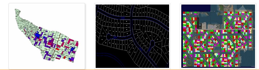
Data layers: GIS works by layering multiple datasets on a single interactive map. For example, a city’s GIS might have separate layers for roads, buildings, population demographics, and utility lines.
patial analysis: Analysts can perform complex spatial analysis by overlaying and examining the relationships between different data layers. This can reveal patterns, trends, and connections that are not obvious in a spreadsheet.
Visualization: GIS data can be visualized in many ways, such as heat maps for density, bubble maps for quantity, or category maps for different land uses.
Cadastral mapping
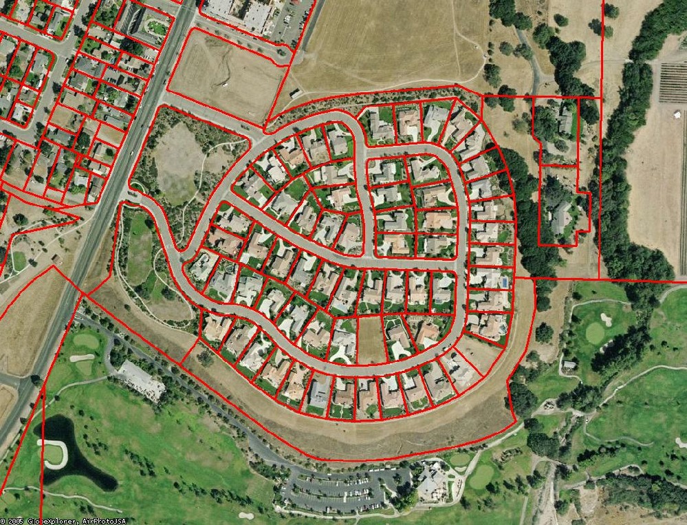
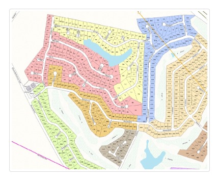
Cadastral mapping is the practice of creating and maintaining detailed, legally recognized maps that show land parcel boundaries, ownership, and other property-related details. A collection of these maps is known as a cadastre
How GIS enhances cadastral mapping
GIS and cadastral mapping are not mutually exclusive; modern cadastral systems rely heavily on GIS technology to function effectively.
Digitization: GIS converts traditional paper cadastral maps into digital formats, making them easier to store, access, and update.
Data integration: GIS allows cadastral data to be layered with other geographic information, such as topographic features, infrastructure, and zoning regulations. This provides a more comprehensive view of the land.
Increased accuracy: The integration of modern surveying tools like GPS and drones with GIS software enhances the precision of cadastral maps.
Enhanced transparency: By putting digital cadastral records online, citizens can easily view land ownership and boundaries, which helps reduce fraud and administrative delays
What is GIS Mapping?
Geographic Information Systems (GIS) is a framework that allows users to capture, store, analyze, and visualize spatial data. It transforms raw geographical information into actionable insights by overlaying multiple datasets on digital maps.
GIS mapping enables the integration of diverse data sources—satellite imagery, GPS, surveys, and sensors—to create detailed, interactive maps. These maps can display everything from land ownership boundaries to population density, infrastructure networks, natural resources, and environmental conditions.
GIS is not just a mapping tool; it is an analytical platform that supports decision-making in urban planning, resource management, environmental protection, transportation, and disaster preparedness.
Importance of GIS in Modern Applications
GIS mapping is indispensable because it allows:
- Visualization of Complex Data – Simplifies interpretation of spatial data for stakeholders.
- Integration of Multiple Datasets – Combines socio-economic, environmental, and infrastructural data.
- Improved Decision-Making – Helps policymakers design evidence-based strategies.
- Monitoring & Management – Tracks urban growth, environmental change, and land use.
- Accessibility – Cloud-based GIS platforms allow data sharing in real time.
What is Cadastral Mapping?
A cadastral map is a comprehensive record of the boundaries, ownership, and value of land parcels within a specific jurisdiction. Cadastral mapping is a cornerstone of land administration systems and serves as the legal basis for property rights and taxation.
Traditional cadastral maps were hand-drawn, often prone to inaccuracies and disputes. Today, modern cadastral mapping relies on satellite imagery, GPS, LiDAR, and GIS to create precise digital maps.
Functions of Cadastral Mapping:
- Defines legal ownership and boundaries of land parcels.
- Provides data for land valuation and taxation.
- Assists in resolving property disputes.
- Supports urban and rural planning.
- Facilitates land registration and titling.
Evolution of Cadastral Mapping
- Conventional Cadastral Mapping – Paper-based, surveyed using chains, compasses, and theodolites.
- Digitization of Maps – Conversion of paper maps into digital formats using CAD software.
- GIS-Integrated Cadastre – Smart systems integrating ownership, taxation, and geographic data.
- 3D & 4D Cadastre – Advanced cadastral systems recording multi-dimensional land and property rights.
- Blockchain for Land Records – Emerging systems ensuring transparent, tamper-proof property registration.
Integration of GIS with Cadastral Mapping
When GIS and cadastral mapping are integrated, they provide powerful tools for land administration and resource management.
- GIS enables analysis of cadastral data by overlaying ownership with environmental, infrastructural, and socio-economic datasets.
- It helps visualize land disputes, encroachments, and planning issues.
- Integration allows governments to modernize land registration systems and reduce corruption.
- It facilitates spatial planning by aligning cadastral boundaries with land use and zoning regulations.
Key Components of GIS & Cadastral Mapping
- Spatial Data – Satellite images, aerial surveys, GPS points, and LiDAR data.
- Attribute Data – Ownership records, land value, and legal descriptions.
- Hardware & Software – GIS platforms (ArcGIS, QGIS), servers, GPS devices.
- Human Resources – Surveyors, GIS analysts, land administrators.
- Legal Framework – Land laws, policies, and governance systems.
Applications Across Sectors
1. Land Administration & Property Management
- Maintaining transparent land records.
- Preventing illegal land grabbing and encroachments.
- Reducing land disputes through accurate boundary demarcation.
- Supporting e-governance and digital land registration.
2. Urban Planning & Smart Cities
- Designing infrastructure layouts (roads, sewage, power).
- Zoning regulations and land use management.
- Planning transport corridors and housing projects.
- Building 3D city models for smart governance.
3. Infrastructure Development
- Route alignment for highways, railways, and pipelines.
- Land acquisition and compensation planning.
- Monitoring construction progress.
- Utility corridor mapping (water, gas, electricity).
4. Agriculture & Rural Development
- Identifying ownership for subsidy allocation.
- Managing irrigation systems and crop zones.
- Preventing land fragmentation.
- Encouraging precision farming with spatial data.
5. Environment & Natural Resource Management
- Mapping forests, wetlands, and protected areas.
- Monitoring deforestation and land degradation.
- Planning sustainable resource use.
- Supporting climate adaptation strategies.
6. Disaster Management & Risk Mitigation
- Mapping flood-prone areas.
- Identifying safe zones for evacuation.
- Planning post-disaster rehabilitation.
- Assessing earthquake vulnerability of buildings and land.
Benefits of GIS and Cadastral Mapping
- Accuracy – High precision in defining boundaries.
- Transparency – Reduces corruption and illegal land transfers.
- Efficiency – Saves time in planning and governance.
- Conflict Resolution – Minimizes disputes between owners and government.
- Revenue Generation – Supports taxation and land valuation.
- Sustainability – Promotes efficient land use and resource conservation.
Challenges & Limitations
- High Costs of technology and skilled manpower.
- Data Accuracy Issues due to outdated records.
- Resistance to Change from traditional systems.
- Legal & Institutional Barriers in implementing modern cadastre.
- Data Privacy Concerns in digital records.
Future Trends with AI, IoT, and Blockchain
- AI & Machine Learning – Automated land classification, encroachment detection.
- IoT Integration – Real-time monitoring of land and infrastructure.
- Blockchain – Secure, tamper-proof land ownership records.
- 3D/4D Cadastre – Managing underground utilities and multi-storey buildings.
- Cloud-Based Platforms – Easy access and sharing of cadastral data globally.
Conclusion
GIS mapping and cadastral mapping together form the backbone of modern land management systems. They not only ensure secure property rights and efficient taxation but also support sustainable development across sectors like urban planning, infrastructure, agriculture, and disaster management.
With technological innovations like AI, IoT, and blockchain, the future of GIS-integrated cadastral mapping will be more transparent, accurate, and citizen-friendly. Governments, private organizations, and communities must invest in these solutions to create efficient, fair, and future-ready land administration systems.