
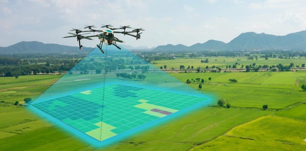
DRONE SURVEY & MAPPING
Land assessors lead reviews from the sky rather than the land by utilizing drones. The truth of the matter is that the information caught through drone planning will impeccably supplement what the architects can see starting from the earliest stage. The drone planning answer for independent flights takes out a few dangers related with land studying like hefty hardware and risky wounds.
Our property drone study by our master group offers high overview speed and exactness, negligible and effective spending use, time-proficient, and more secure single device activity to study significant spaces of land territory. Likewise, this sped up and mechanization that drone planning gives grant organizations to securely take on and complete more positions for customers, on more locales in less time.
Drone Mapping & Inspection — Course Outline
Regulations & Permissions
- Regulations of DGCA
- Permissions and Digital Sky
- Commercial Operations
- Drone Equipment
- Different types of Drones
- Gimbal Balancing
Aerial Photogrammetry
- Principles of Photogrammetry
- Photogrammetric Procedures
- Error Adjustment
- Georeferencing
- Aerial Triangulation
- Spatial Reference Systems
Introduction to Mapping
- Introduction to Mapping
- Types of Mapping
- Platform and Payload Considerations
- Mapping for Construction
- Mapping for Agricultural Uses
- Mapping for Engineering Purposes
Mapping & Modelling for Aerial Drone Inspections
- Fundamentals of Mapping & Modelling
- Mapping Software Overview
- Utilizing Mapping Software for Aerial Drone Inspections
Getting Started with DroneDeploy
- Autonomous Flight Planning
- Waypoints
- Collecting Imagery for 2D Mapping
- Ground Control Points (GCPs)
- Creating GCPs
- Placing GCPs
- Utilizing the GCP Checklist
- Submitting GCPs in DroneDeploy
Elevations & 3D Modelling
- Collecting Oblique Imagery for 3D Modelling
- Orbit at End of Mission
- Manual Collection
- Using the Map Engine
- Map Engine Processing Options
- Map Engine Data Requirements
- Data Submission
- Accessing the Final Product
- Uploading the Data
Data Analysis
- Analysis and Evaluation of Data
- Performing Volumetric Calculations
- Cut, Fill, and Volumetric Measurement Calculation
- Lowest Point and Best Fit Base Planes
- Relative vs. Absolute Accuracy
- Project Accuracy Requirements
- Survey-Grade Accuracy
- Techniques to Improve Map Accuracy
Aerial Drone Inspection Techniques
- Types of Imagery Products
- Areas of Focus
- Manual Flight Profiles
- Common Manual Images
- Determining the Image List
- Sample Image Lists
- Proper Imagery Analysis
- Environmental Impacts
- Image Framing
- Common Camera Settings
- Speciality Camera Settings
Introduction to Thermal Imaging
- Fundamentals
- Types of Thermal Payloads
- Types of Thermal Inspections
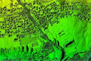
Digital Surface Models (DSM)
Drone images can also be used to create DSM models of the area. Each pixel contains 2D information (X, Y) and the altitude (Z value) of the highest point for this position.
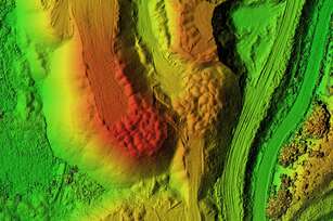
Contour Maps
Depending on the project requirements, either the DTM or DSM model, with custom contour intervals, can be used to create a contour lines map, giving you a better understanding of the surface of the area shot by the drone.

Digital Terrain Model (DTM)
Following the removal of objects like buildings, the drone images can be utilized to construct Digital Terrain Models (DTMs). In these models, each pixel stores 2.5D information, including the X, Y, and Z values corresponding to the highest altitude.
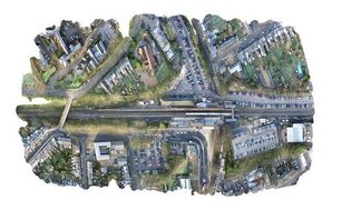
Orthomosaic Maps
Drone images undergo correction for image distortion and are seamlessly merged during post-processing to generate a remarkably precise orthomosaic map. Every pixel within this map carries detailed 2D geographic data (X, Y), enabling precise measurements like horizontal distances and surface areas to be directly obtained.
3D Point Cloud
Drone images can be processed to produce a dense point cloud. Each point within this cloud encapsulates geospatial coordinates (X, Y, Z) and color details, furnishing a highly accurate model for measuring distances (both slant and horizontal), as well as determining areas and volumes.
