
GROUND PENETRATING RADAR (GPR) SURVEYS
Introduction to GPR Surveys
Ground Penetrating Radar (GPR) is one of the most advanced non-destructive geophysical survey methods used to investigate subsurface conditions. It employs electromagnetic waves to detect objects, changes in material properties, voids, and cracks beneath the ground or within structures. Unlike traditional excavation or drilling, GPR provides a fast, cost-effective, and non-invasive way to explore subsurface features
GPR has found applications across a wide range of industries including civil engineering, construction, road and bridge assessment, archaeology, utilities, mining, and environmental studies. With advancements in radar technology, GPR surveys have become more accurate, portable, and versatile, making them an essential tool for modern infrastructure and scientific studies.
Introduction to GPR Surveys
Working Principle of GPR
Components of GPR Systems
Types of GPR Surveys
Applications in Civil Engineering
Applications in Geotechnical & Environmental Studies
Applications in Archaeology & Forensics
Applications in Utilities & Infrastructure Mapping
Advantages of GPR Surveys
Limitations & Challenges
Comparison with Other Survey Techniques
Future of GPR Technology
Conclusion
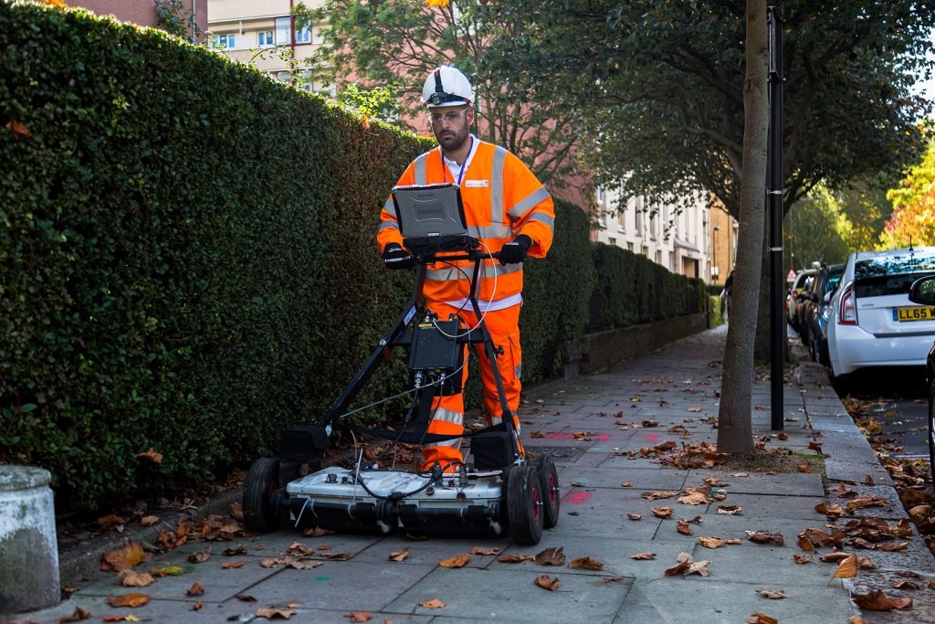
Components of GPR Systems
A typical GPR system includes:
- Control Unit – Manages power, data recording, and user interface.
- Transmitting Antenna – Sends electromagnetic pulses.
- Receiving Antenna – Captures reflected signals.
- Data Logger/Computer – Processes and stores information.
- Software – Converts signals into radargrams for interpretation.
Modern GPR systems also integrate GPS for georeferencing, 3D imaging capabilities, and wireless data transfer.
Types of GPR Surveys
1. Surface-Based GPR Surveys
Conducted by moving antennas across the ground surface. Ideal for roads, pavements, and utility mapping.
2. Borehole GPR Surveys
Antennas are lowered into boreholes to scan deeper subsurface features. Useful for geotechnical and groundwater studies.
3. Air-Coupled GPR Surveys
Antennas are mounted on vehicles or drones above the surface. Widely used for highway and bridge deck assessments.
4. 3D GPR Surveys
Multiple parallel survey lines are combined to create a 3D volume model of the subsurface. This is highly effective in archaeology, construction, and forensic studies.
Applications of GPR Surveys in Civil Engineering
1. Concrete Assessment
- Detecting reinforcement bars, voids, and cracks.
- Measuring concrete thickness.
- Identifying areas of deterioration in bridges and tunnels.
2. Road and Pavement Analysis
- Determining pavement layer thickness.
- Locating voids and moisture accumulation.
- Assessing deterioration before major repairs.
3. Bridge Deck Surveys
- Identifying corrosion in rebar.
- Locating delamination zones.
- Assessing overall bridge health.
4. Tunnel and Structural Surveys
- Mapping lining thickness.
- Detecting cracks or water ingress.
- Ensuring safety of underground infrastructure.
Applications in Geotechnical & Environmental Studies
- Soil Stratigraphy – Mapping layers of soil and rock.
- Groundwater Studies – Identifying water table depth.
- Landfill Investigations – Detecting buried waste and contamination.
- Hazard Detection – Locating sinkholes, voids, and unstable ground.
GPR provides essential data for safe foundation design, slope stability, and construction planning.
Applications in Archaeology & Forensics
Archaeology
- Locating buried structures, walls, and foundations.
- Mapping ancient settlement sites.
- Identifying tombs and graves without excavation.
Forensics
- Locating clandestine graves.
- Recovering buried weapons or evidence.
- Assisting law enforcement in crime investigations.
GPR has revolutionized archaeology by allowing non-invasive exploration, preserving historical sites while still uncovering hidden features.
Applications in Utilities & Infrastructure Mapping
- Detecting underground utilities such as pipes, cables, and conduits.
- Avoiding damage during excavation.
- Mapping congested utility corridors in urban areas.
- Supporting smart city planning with accurate subsurface data.
GPR helps reduce accidents, prevent service disruptions, and improve construction efficiency.
Advantages of GPR Surveys
- Non-Destructive – No digging or drilling required.
- Fast and Efficient – Large areas can be surveyed quickly.
- High Accuracy – Detects subsurface features with precision.
- Versatile – Works across soil, rock, concrete, and ice.
- Cost-Effective – Reduces need for expensive exploratory excavation.
- Real-Time Results – Data can be viewed instantly in the field.
Limitations & Challenges
- Depth Limitation – Maximum penetration is around 30 m (in dry conditions).
- Soil Conditions – Performance reduces in clay-rich or saline soils due to signal attenuation.
- Interpretation Complexity – Requires trained experts to analyze radargrams.
- Equipment Cost – High-quality GPR systems are expensive.
- Regulatory Restrictions – In some regions, frequency use is regulated.
Comparison with Other Survey Techniques
| Method | Depth | Resolution | Non-Destructive | Speed | Best Use Case |
|---|---|---|---|---|---|
| GPR | Up to 30 m | High | Yes | Fast | Utilities, concrete, archaeology |
| Seismic Survey | 100+ m | Moderate | Yes | Slower | Geological mapping, oil exploration |
| Electrical Resistivity | 50–100 m | Low–Moderate | Yes | Moderate | Groundwater, soil layers |
| Magnetometry | Variable | Low | Yes | Fast | Archaeology, mineral exploration |
This comparison shows GPR as a superior choice for shallow, high-resolution surveys.
Future of GPR Technology
The future of GPR surveys looks promising with technological advances:
- Integration with AI and Machine Learning – Automating radargram interpretation.
- 3D and 4D GPR Imaging – Real-time visualization of subsurface changes.
- Drone-Mounted GPR Systems – Extending coverage in inaccessible areas.
- Miniaturization – Portable systems for handheld use.
- IoT Integration – Real-time data sharing for smart infrastructure management.
These innovations will make GPR even more versatile, efficient, and accessible.
Conclusion
Ground Penetrating Radar (GPR) surveys have become an essential tool for modern engineering, archaeology, environmental studies, and infrastructure management. With its ability to provide accurate, fast, and non-destructive subsurface insights, GPR reduces risks, saves costs, and enhances project efficiency.
Whether it is locating utilities in a busy city, assessing bridge conditions, uncovering ancient structures, or mapping geological features, GPR stands out as a reliable and future-ready technology.
As integration with AI, drones, and smart infrastructure continues to evolve, GPR will play a central role in shaping safer, smarter, and more sustainable development across industries.