
AIRBPRNE & DRONE LIDAR
Introduction to LiDAR Technology
In the last two decades, LiDAR (Light Detection and Ranging) has emerged as one of the most transformative geospatial technologies. It works by emitting laser pulses towards a surface and calculating the time it takes for the reflected signal to return, thereby measuring distance with extreme accuracy. LiDAR produces high-resolution 3D point clouds, enabling professionals to analyze terrain, structures, vegetation, and infrastructure with unmatched precision.
Introduction to LiDAR Technology
Airborne LiDAR: Overview, Working, Applications
Drone LiDAR: Overview, Benefits, Applications
Comparison: Airborne vs. Drone LiDAR
Key Advantages of LiDAR in Modern Industries
Applications Across Sectors (Construction, Roads, Mining, Forestry, Utilities, Smart Cities, Disaster Management, etc.)
Challenges and Limitations
Future Trends of LiDAR with AI, GIS, and Digital Twins
Conclusion
While ground-based LiDAR has its importance, two modern forms—Airborne LiDAR and Drone-based LiDAR—have completely redefined the possibilities in surveying, mapping, and data collection. They provide faster coverage, detailed outputs, and are capable of operating in challenging environments where traditional surveying would be impractical or unsafe.
This article provides a comprehensive understanding of Airborne and Drone LiDAR technologies, their benefits, applications, differences, challenges, and future scope.
Airborne LiDAR Technology
What is Airborne LiDAR?
Airborne LiDAR refers to laser scanning systems mounted on aircraft such as airplanes or helicopters. These systems scan vast areas of land by emitting thousands of laser pulses per second. The reflected data is combined with GPS and Inertial Measurement Unit (IMU) readings to produce accurate Digital Elevation Models (DEM), Digital Terrain Models (DTM), and 3D surface models.
Working Principle
- A laser scanner mounted on the aircraft emits continuous pulses.
- The time delay between emission and reflection is recorded to calculate distance.
- GPS data provides geographic positioning, while IMU data captures orientation and altitude.
- The final result is a dense point cloud dataset covering large terrain areas.
Advantages of Airborne LiDAR
- Covers large areas quickly, ideal for regional or national projects.
- Capable of capturing data over forests, mountains, rivers, and inaccessible terrain.
- Generates high-resolution topographic maps with centimeter-level accuracy.
- Penetrates vegetation, making it extremely useful for forestry and ecological studies.
Applications of Airborne LiDAR
- Topographic Mapping – Used for national mapping programs and large-scale survey projects.
- Forestry Management – Estimation of tree height, canopy density, and biomass.
- Coastal Monitoring – Mapping shorelines, erosion patterns, and floodplain modeling.
- Urban Planning – Capturing entire city landscapes for planning and development.
- Disaster Management – Assessing flood risks, landslides, and post-disaster damage.
Drone LiDAR Technology
What is Drone LiDAR?
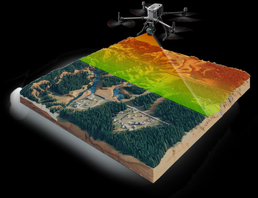
Drone LiDAR uses Unmanned Aerial Vehicles (UAVs) equipped with LiDAR sensors. Unlike manned aircraft, drones provide flexibility, cost efficiency, and rapid deployment for localized projects. Drone LiDAR has grown in popularity due to the availability of compact and lightweight sensors that can be mounted on commercial drones.
How Drone LiDAR Works
- A drone flies autonomously or manually across the survey area.
- The onboard LiDAR sensor collects data while the drone maintains a low-altitude flight path.
- Data is combined with GPS and IMU for positional accuracy.
- Outputs include high-density point clouds, 3D models, and terrain analysis maps.
Advantages of Drone LiDAR
- Cost-effective compared to airborne LiDAR.
- Ideal for small to medium-scale projects.
- Can access tight or hazardous areas (construction sites, mines, disaster zones).
- Offers faster turnaround time for data collection and processing.
- Provides high point density, making it suitable for detailed mapping.
Applications of Drone LiDAR
- Construction & Infrastructure – Progress monitoring, volumetric analysis, and layout verification.
- Road & Highway Projects – Alignment surveys, pavement assessment, and corridor mapping.
- Mining – Volume calculation of stockpiles, slope monitoring, and site safety assessments.
- Utilities – Powerline inspection, pipeline monitoring, and right-of-way analysis.
- Forestry & Agriculture – Crop health monitoring, canopy penetration, and precision farming.
- Disaster Response – Rapid assessment after earthquakes, landslides, or floods.
Comparison: Airborne vs. Drone LiDAR
| Feature | Airborne LiDAR (Aircraft) | Drone LiDAR (UAV) |
|---|---|---|
| Coverage Area | Very large (hundreds of km²) | Small to medium (few km²) |
| Altitude | High altitude (500–3000m) | Low altitude (50–200m) |
| Point Density | Moderate | Very high (fine detail) |
| Cost | High (aircraft operation cost) | Lower (affordable for SMEs) |
| Flexibility | Low (requires flight permits) | High (quick deployment) |
| Use Cases | Regional mapping, forestry, coastal studies | Construction, mining, utilities, local projects |
Both technologies complement each other. Airborne LiDAR is best for large-scale regional mapping, while Drone LiDAR is perfect for localized, detailed projects.
Key Advantages of LiDAR in Modern Industries
- High Accuracy – Centimeter-level precision.
- Speed – Rapid data collection compared to traditional surveys.
- 3D Visualization – Generates highly detailed 3D models for better analysis.
- Penetration – Can measure ground beneath vegetation.
- Automation – Compatible with AI and GIS for smart analysis.
Applications Across Different Sectors
- Construction & Infrastructure
- Monitoring site progress.
- Checking earthwork volumes.
- Planning road alignments and bridges.
- Transportation & Roads
- Designing highways and railways.
- Pavement quality analysis.
- Corridor planning and safety checks.
- Forestry & Environment
- Canopy height analysis.
- Wildlife habitat monitoring.
- Deforestation studies.
- Mining & Quarrying
- Volume and stockpile measurements.
- Safety monitoring in hazardous areas.
- Utilities & Energy
- Monitoring powerlines, pipelines, and solar farms.
- Detecting vegetation encroachment.
- Disaster Management
- Flood modeling, landslide prediction, and rapid post-disaster surveys.
- Smart Cities & Urban Planning
- 3D city models for planning.
- Infrastructure monitoring.
- Utility corridor mapping.
Challenges and Limitations
- High Costs of sensors and processing software.
- Regulatory Restrictions on drone and aircraft operations.
- Weather Dependency – Cloud cover, rain, or strong winds affect data quality.
- Data Processing Complexity – Requires skilled professionals and powerful computing.
Future Trends in LiDAR
The future of Airborne and Drone LiDAR looks promising with rapid advancements:
- Integration with AI & Machine Learning for automated feature extraction.
- Digital Twin Creation using LiDAR data in smart cities.
- Miniaturization of Sensors for wider adoption in drones.
- Fusion with Photogrammetry & GIS for richer datasets.
- Autonomous Vehicles – LiDAR is a core component of self-driving technology.
Conclusion
Airborne and Drone LiDAR technologies are revolutionizing surveying, mapping, and monitoring in almost every sector. Airborne LiDAR remains the preferred choice for large-scale projects like national mapping and forestry, while Drone LiDAR has become indispensable for local, high-detail applications such as construction, mining, and utilities. Together, they offer unmatched accuracy, efficiency, and versatility in geospatial data collection.
As industries move towards digital transformation and smarter infrastructure, LiDAR will continue to play a central role in shaping sustainable, safe, and efficient development.